While sitting around in late winter, being thoroughly tired of all its snow and record cold in February, we wanted to plan a springtime weekend getaway that was simple and sweet. Without benefit of watching the movie "The Bridges of Madison County" to serve as inspiration, we suddenly struck on the idea of visiting some of the covered bridges right here in Northeast Ohio.
There are over 125 covered bridges in Ohio, second only to Pennsylvania in number (so let's build some more so we can take the lead!). We decided that we would spend a weekend in June visiting the 17 that adorn the countryside of Ashtabula, and the 1 in the City of Geneva.
We were fortunate that the weekend we had picked was one of the few with beautiful weather in June this year. Saturday morning brought bright sunshine and temps starting in the low 60's, never climbing above 70. Sunday was just as nice, and just a little bit warmer.
When we travel, we have a strange penchant for travelling "widdershins" (look it up). We left our home in Cleveland Heights, travelled out Route 322 (Mayfield Road) to the first covered bridge, zigzagged our way up toward the northeast corner of Ohio for our overnight stay in Conneaut, and on the morning of Day 2 we shouted "Westward Ho!" (well, we didn't, actually, but we may have thought it) and headed out for the remaining bridges. The whole trip was done in a counterclockwise fashion (oops, I just revealed what widdershins means).
You can drive over (or should I say on/through) all but 1 of the bridges. All have at least one area you can pull off the road to park in if you want to go take a closer look at the bridge. Some bridges disallow trucks and busses due to low head room or the inability to support the weight of heavy vehicles. Cars are OK, and we saw lots of pickup trucks crossing bridges so they must be OK, too. If in doubt, it's best to stay off.
Since we weren't in any hurry to get to any of the bridges, I told our GPS to take us on the shortest route instead of the fastest one. I figured this would get us on some back roads that might have some interesting things to see. Many of the bridges are on gravel roads (whether you've chosen the shortest route or the fastest one makes no difference), so prepare to get dusty (both you and your vehicle).
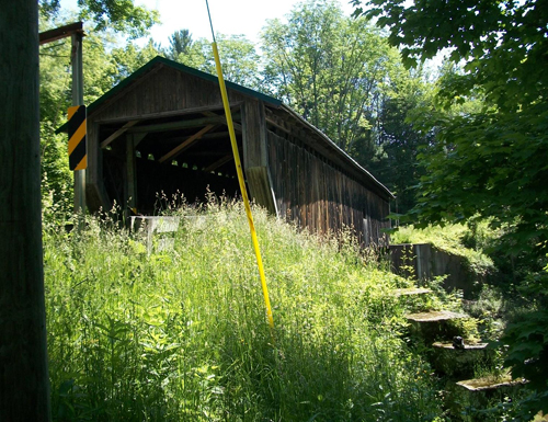
Our first covered bridge was on Warner Hollow Road, just south off Route 322. Built in 1867, its 120' length spans Phelps Creek, a tributary of the Grand River. It is listed on the National Register of Historic Places. As we stood there admiring the bridge, an Amish couple quickly crossed in their horse-drawn buggy, but too quickly for me to snap a photo.
 Warner Hollow
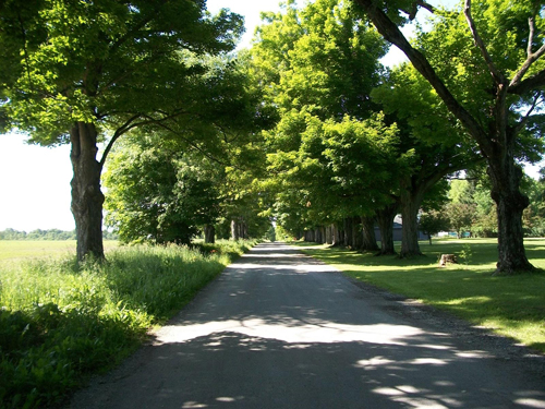 Sugar maple allee
Also along the way were a couple of huge turkey vultures having a roadside brunch. They briefly (and quite reluctantly) flew up into a nearby tree as we approached, but quickly resumed their meal after we passed. As we drove by I assured them that we had no interest in what they were feasting on.
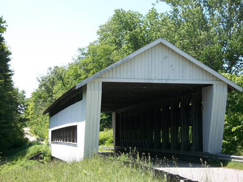
Riverdale Bridge is 114 feet long and spans the Grand River. Built in 1874, the floor needed to be rebuilt in 1981, but it's sturdy enough now to drive on.
 Riverdale Bridge
The Doyle Road Bridge (94 feet long, spanning Mill Creek) is interesting in that it has a wagon wheel on each end.
It was also interesting because there was a cat sitting on one of the abutments vocalizing about something or other, but I don't think it was an official part of the bridge.
 Doyle Bridge
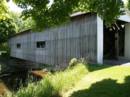
Giddings Road Bridge (107 feet, also over the Mill Creek) was one of the more "open" bridges, with lots of spaces to look at Mill Creek beneath.
 Giddings Road
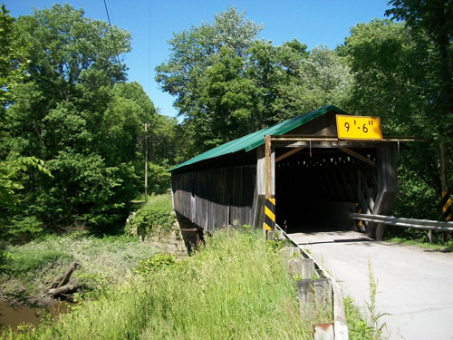
Netcher Road Bridge (110 feet long) had an interesting roof design reminiscent of a barn with an opening to the hayloft, and a narrow "cupola" on each peak. Like the Giddings and Doyle Road Bridges, it also spans Mill Creek.
 Netcher Road
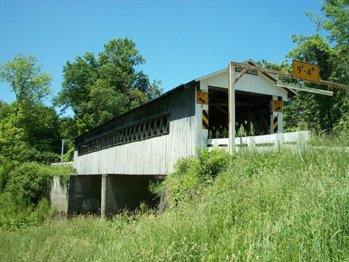
We had a little difficulty finding our next bridge on S. Denmark Road, mainly because my GPS told us to turn left and we should have turned right. Had we only looked to our right before we turned, we would have seen one of the many signs that mark the covered bridges route (did I forget to tell you they have these signs?). We soon learned the error of our way when Mandy (our nickname for the GPS's voice) said "You have reached your destination" and we were adjacent to an open field.
On a hunch that the bridge wasn't going to be further up the road, we turned around and headed back the way we had come, and saw the sign pointing the way to the bridge. At 81 feet long, it is one of the shortest ones on the tour. It is off the main road and all the traffic we saw on the road skipped driving through it.
 S. Denmark Road
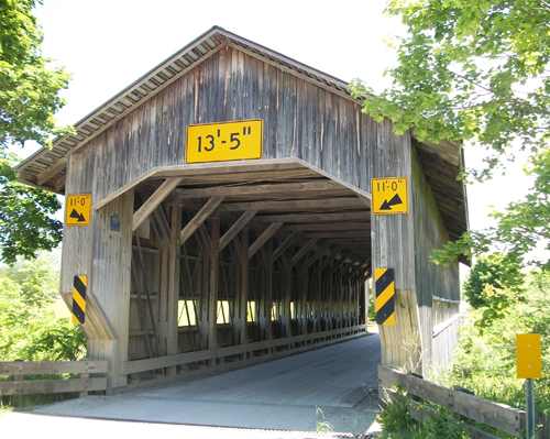
Caine Road Bridge
Graham, Root and State Road bridges soon followed. The Graham Bridge is the one you can't drive on. It was built from the remains of a bridge that had washed downstream in 1913 and it now sits in a small off-road park. It is one of the bridges and buildings sporting one of over 50 "barn quilts" found throughout Ashtabula County. Barn quilts are pieced wooden quilt patterns in bright colors, and that's a whole 'nother tour you can go on.
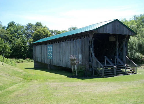 Graham Road Bridge
There's a picnic table at its far end, so if you've brought your pickanick-type basket, here's a great little spot. We were feeling a bit peckish at this point of our journey and would have welcomed a little snack, but sadly we had none (but next time we will, probably some cheese and fruit). There aren't any restaurants very close by, so you may want to bring something along if you think this'll be a place you want to rest a bit.
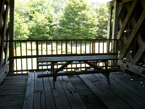 Graham Road picnic bench
I particularly enjoyed the sturdy construction (not that the other bridges aren't sturdily-constructed) of the Root Road Bridge. The X-shaped braces and thick, laminated trusses screamed strength.
 Root Road Bridge
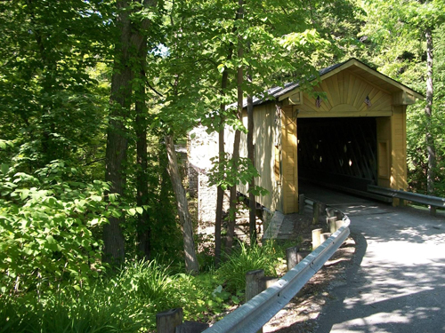
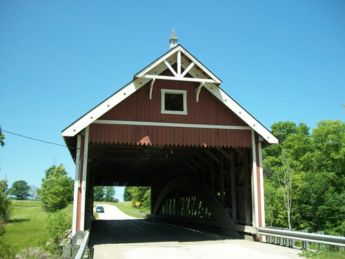
The State Road Bridge was the first designed and built by John W. Smolen, Jr., County Engineer. Erected in 1983, at 152' it spans Conneaut Creek, and contains 97,000 feet of southern pine and oak. The entire length of the bridge is open-sided, which highlights the lattice-type construction.
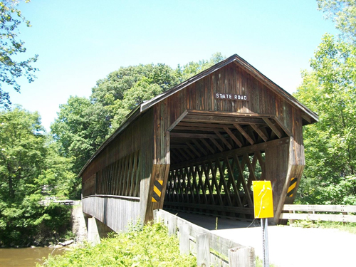 State Road Bridge
The Middle Road Bridge, built in 1868, rounded out our first day of "bridging." Its 136' span traverses Conneaut Creek, which happens to be the longest river in eastern Ashtabula County (so is it a creek or a river?).
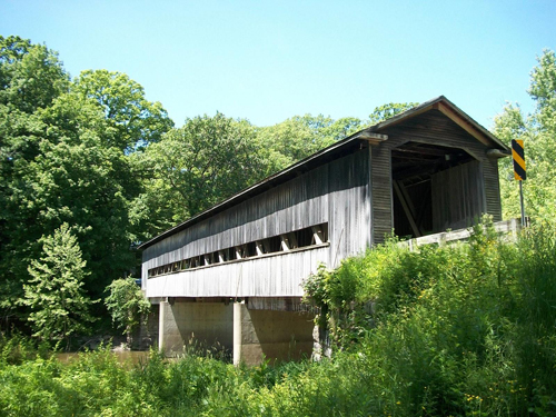 Middle Road Bridge
Mid-afternoon found us in the City of Conneaut. We decided it was way past lunchtime and time to eat, so we headed for the downtown area. We arrived to discover that the streets were blocked off for some reason, so we parked in a nearby lot and walked in. Turns out they were having a sock hop and vintage car show, and we had gotten there just as the activities were beginning. The whole town had turned itself into a festival, with bands, cars, motorcycles, and food vendors up and down the streets.
We had a great lunch at the Rainbow Café, starting with the Italian wedding soup (highly recommended), then walked the streets inspecting the cars. There must have been over 200 cars of all makes, models and years. The locals told us that the streets are filled at night with people dancing (hence the sock hop part).
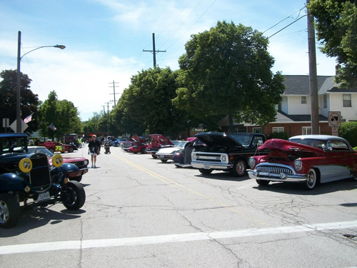 Conneaut car show
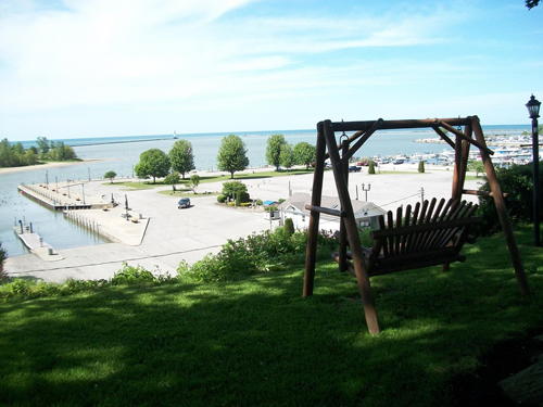
Making our way closer to the shores of Lake Erie, we arrived at our overnight lodgings on Park Avenue, the Lakefront Motel. This is a quaint motel with only 8 rooms. The rooms are small but clean and comfortable, with good cable and A/C, just what we needed for the night. Like in the song, "King of the Road" -- no phone, no pool, no pets (well, we're not positive about the no pets part) - so be sure to bring your cellphone if you want to stay in touch. A short walk from our door there was a nice expanse of lawn with shade trees, tables, chairs and a 2-person wooden swing where we enjoyed a beautiful view of Lake Erie and the marina.
The other 7 rooms were filled with a group of motorcyclists from the Steubenville area who were in town for a weekend jaunt themselves. They told me that they come up a few times a year, always staying at this motel, just to enjoy the area and to see Lake Erie. We enjoyed a lot of friendly conversation while viewing the harbor and lake, and again the next morning as they prepared to head home, and we on our trek. Definitely a place we would stay at again.
After checking in, our primary mission was finding a place for dinner (always a priority), with fresh fish in mind. This led us to the marina, where we spotted the perfect place (more to come). That important decision made, we decided to explore a little more.
As we toured the harbor we of course saw lots of boats and fishermen. By the way, the Seneca Indians called the creek that empties into Lake Erie at this point Konyiat, meaning "place of many fish", and that's how the city got its name. It's still a destination for fishermen from all over. I always carry a small fishing rod in my trunk just in case, but time was running short and I resisted the temptation.
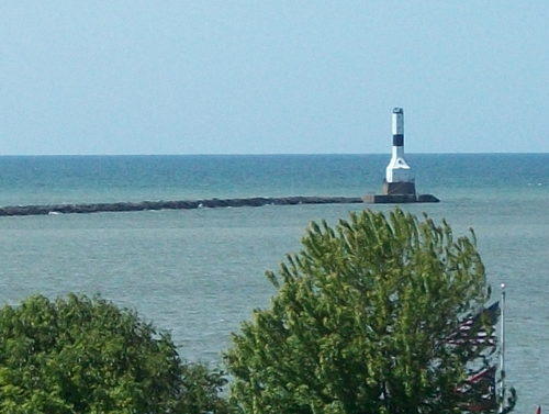
We drove around to the west side of the marina to go toward the lighthouse. Plenty of beach space, with people flying kites, picnicking and walking their dogs. Easy access, you can drive right in.
The Conneaut lighthouse is privately owned so you can't tour it, but it's clearly visible from the entire area. Originally built in 1835, it served as the main marker for one of America's biggest ports in the 20th century.
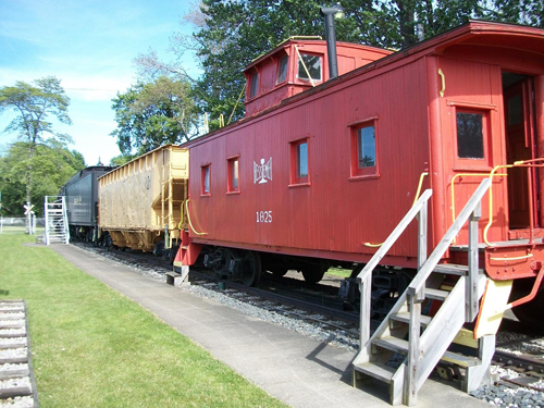
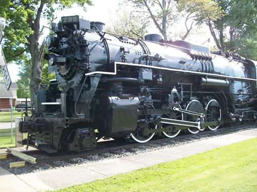
We had heard about a railroad museum not too far from the motel, so we decided to investigate. The museum is housed in a former New York Central depot, built around 1900. Admission is free, but donations are certainly welcome.
We arrived only about 30 minutes before closing, but the lady (a volunteer) minding the museum said she didn't mind staying over for us, she wanted us to be able to enjoy the museum. Enjoy we did, as we checked out the incredible collection of railroad memorabilia and, of course, train cars. A railroad buff could easily get lost here for hours examining the exhibits.
While talking with the volunteer, we learned of a D-Day invasion re-enactment they put on every year in August, since 1999. It's the largest WWII living history event in the U.S., with training exercises, weapons, vehicles and over 1,000 re-enactors. You can watch the Allied forces' amphibious landings while military aircraft patrol overhead, and meet with WWII veterans as they share their personal experiences. For more info, visit www.ddayohio.us.
For dinner, we went back to the restaurant in the harbor that we had previously decided on - the Breakwall BBQ -- where we had some great perch. They barbecue right outside, but we wanted dinner fare from Lake Erie. It was plentiful and delicious.
We were serenaded during dinner by a Beach Boys/Margaritaville/Oldies live band out on the deck. We were seated inside at a table by the window so we could enjoy both the music and the view. If you get there early enough on a Saturday, you might be able to have one of their burgers. They make only 40 burgers, and that's it. As the menu says, if you're #41, you're "SOL my friend." Our server told us that people come back weekly trying to be one of the lucky ones getting a burger. Must be an awfully good burger, and it's definitely an awfully good marketing technique.
Although our perch dinners filled us, we couldn't resist the temptation of their locally-made desserts, so we asked our server to box up a couple chocolate cupcakes, with plans to enjoy them later that evening. We like a cup of hot tea in the evening and often travel with a portable electric kettle so that we can make our own tea whenever we want. The tea was a great accompaniment to the cupcakes (or vice versa). One last visit to the bluff overlooking the lake capped off a perfect day with a perfect ending, a la a beautiful sunset.
Page 2 (of 2) of the Covered Bridges of Ashtabula County
Top of Page
Back to Travel


 Home
Home
 Arts & Leisure